Improving Efficacy of Tsunami Warnings Along the West Coast of the United States
Published in PAGEOH, 2023
Download here
Published in PAGEOH, 2023
Download here
Published in BSSA, 2023
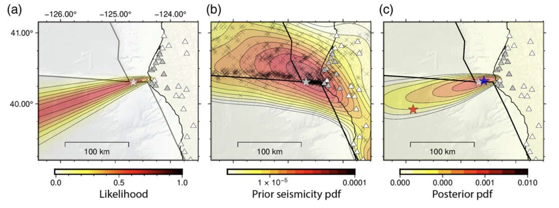
In order to better constrain location solutions in this region, we propose to include information about contemporary past seismicity into EPIC’s grid search algorithm through a Bayesian framework. This prior information layer down-weights high error locations where EPIC’s proposed event location coincides with an area of low prior seismicity in preference for locations with a similar level of data fit that also have higher past seismicity. This addition to EPIC lowers the mean location error offshore northern California from 58 km to 14 km.
Download here
Published in Frontiers in Earth Science, 2020
In this study, we present an approach to estimating inundation depth probabilities (in the form of hazard curves at a set of coastal locations)that consists of two components. The first component uses a Karhunen-Loe`ve expansion to express the probability density function (PDF) for all possible events with PDF parameters that are geophysically reasonable for the Cascadia Subduction Zone (CSZ). It is then extremely easy and computationally cheap to generate a very large N number of samples from this PDF; doing so and performing a full tsunami inundation simulation for each provides a brute force approach to estimating probabilities of inundation. The estimate is simply the number of random realizations that reach specified inundation depth divided by N. However, to obtain reasonable results, particularly for extreme flooding due to rare events, N would have to be so large as to make the necessary tsunami simulations prohibitively expensive. The second component tackles this difficulty by using importance sampling techniques to ensure we adequately sample the tails of the distribution and properly re-weight the probability assigned to the resulting realizations, and by grouping the realizations into a small number of clusters that we believe will give similar inundation patterns in the region of interest.
Download here
Published in Seismological Research Letters, 2020
In thisIn this study, we posit that subaerial, submarine landslides, and coseismic offsets all contributed to the 2018 Palu, Indonesia tsunami’s damaging impact. We explore many possible tsunami sources in addition to the earthquake’s rupture near the bay, solving for both coseismic offsets and potential landsliding events in a self-consistent model.
Download here
Published in JGR Solid Earth, 2020
In this study, we take the first steps to systematically analyze thequality of nearfield tsunami forecasts that would rely on earthquake source products derived from high-rate and real time GNSS data for potential earthquakes originating on the Cascadia margin. Specifically, we focus on two aspects. First, we analyze the ability of regional GNSS sensors to rapidly estimate characteristics of an offshore earthquake such as magnitude, focal mechanism, and fault slip. Second, we show how well automated GNSS-driven slip models can reproduce observed tsunami amplitudes at local coastlines, proposing an assessment method based on user defined thresholds that we believe is beneficial for local tsunami warning.
Download here
Published in JGR Solid Earth, 2019
In this study, we develop a design for the cost‐effective placement of tsunameters around the southern Java region. As a reference for the design, we utilize multiple stochastic tsunami sources generated by hypothetical thrust earthquakes with Mw 8.8–9.2 occurring on the plate interface.
Download here
Published in JGR Space Physics, 2019
In this study, we report the results of numerical simulations of ∼80–90-km altitude airglow disturbances driven by strong acoustic waves excited during a hypothetical nighttime equivalent of the 2011 Tohoku-Oki earthquake (magnitude 9.1).
Download here
Published in Geophysical Journal International, 2019
In this paper we examine the impacts of the homogenous slip model when compared to stochastic slip distributions and ask whether, in light of these technical advancements, the homogenous slip assumption remains a reasonable one.
Download here
Published in JGR Solid Earth, 2018
In this study, we analyze the contribution in resolution that the open-ocean tsunami waveform provides to the inverse problem and how it compliments geodetic data sets for use in subduction zone finite-fault problems.
Download here
Published in JGR Solid Earth, 2017
Through a transcoastal geodetic study, including tsunami time series recorded at open ocean pressure gauges, subaerial deformation observed through interferometric synthetic aperture radar from the Sentinel-1 A satellite and continuous GPS, we identify the location and extent of coseismic slip from the 2015 Illapel, Chile earthquake.
Download here